Online maps created by our users
- Address geocoding from CSV file
- Map of USA states
- Visualize business sales data
- Data mining or marker clustering map
- Filter map markers by category
- Map with routes and multiple layers
- Store locator in France
- Generate maps from spreadsheet data
- ZIP code search on congressional map
- Present multiple database stats
- Density choropleth map
- Census data and demographics map
- Make an online interactive image map
- Route map of rally across provinces
- Crowd sourcing map
- Geographic regions on Google Maps
- Driving routes between locations
- Annotated Interactive Metro Map
Interactive map solution
HTML5 map solution
HTML5 Zip Code Tabulation Area Map Example ( Pennsylvania 5-Digit ZCTA of United States)
Showcase > HTML5 Mapping Solution >
Cross-Platform Interactive Map Sample of Pennsylvania, United States, using HTML5 and SVG to show all the ZIP code areas ZCTAs).
The map can be further themed and customized into a heat map according to imported data.
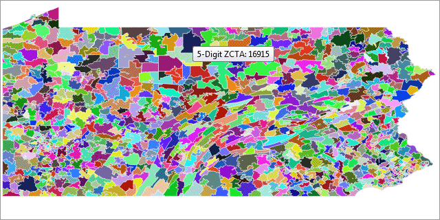
Map Features
- Cross-platform map solution using HTML5 and SVG
- 5-Digit Zip Code Tabulation Area (ZCTA) vector map of U.S.
- Able to change Region and boundary color
Cloud-based Interactive Map Creator
and Image Mapping Tool
Create interactive map, image map, custom Google map with on line editor
- Ready-made map templates of countries & world, easily edit maps in browser
- Feature rich custom style Google map editor: marker clustering & crowdsourcing
- Turn an image into interactive diagram, floor plan, flow chart
![]()

New! iMapBuilder - Interactive HTML5 Map Builder
Creates HTML5 interactive maps for iPad, iPhone, PC, Mac & Android mobile
- Created maps work on PCs, Macs, iPad, iPhone, Android mobile and tablets
- Customize map styles (e.g. color themes) easily using software editor
- Embed maps in web page for online or offline presentation
- Simple, flexible licensing for developers and businesses
![]()
 Scalable & Zoomable Map |
 Cross Platform Support |
 Styled Rollover Info Box |
More info about interactive HTML5 map development Contact Us